Flying in dynamic terrains
Learn what are the best practices when flying in mountains and similar environments where the landscape massively alters.
Flight planning
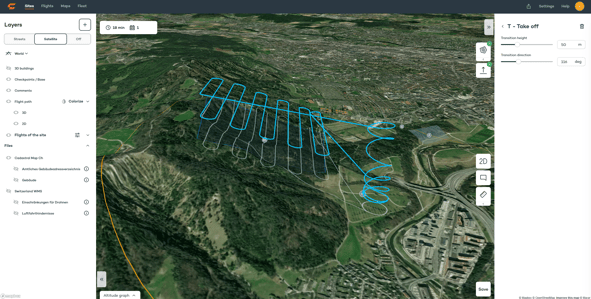
To make the flight safe and at the same time keep the data capture consistent by achieving uniform GSD or point cloud density for Lidar flights, we suggest using WingtraCloud and its 3D flight planning feature. More on that, please check here.
To achieve the above-mentioned goals the flight plans should meet the following criteria:
- Have terrain following always ON. To find more about the terrain following please check here
- Keep Smart RTH always ON. For more about RTH modes please check here.
- Set flight lines parallel to the contour lines of the terrain. To achieve it please move the flight direction slider until the lines are oriented correctly

- In case the terrain massively alters you can achieve the criteria from the bullet above by splitting the areas into subareas, where each one covers the terrain with a similar orientation of contour lines. For each area orient the flight lines in a meaningful way


-
- The users who do 2D flight planning in WingtraHub or WingtraPilot in order to have a better general overview of the terrain you will fly over with your WingtraOne, you can change the map type to Terrain if you are using Google as a map provider in WingtraPilot

- The users who do 2D flight planning in WingtraHub or WingtraPilot in order to have a better general overview of the terrain you will fly over with your WingtraOne, you can change the map type to Terrain if you are using Google as a map provider in WingtraPilot
To make multiple area flights most efficient, make sure you orient the flight lines in a meaningful way. For the example above, it would mean the drone flies A1 bottom to top, A2 top to bottom, and A3 bottom to top.
- Increase the safety parameters and flight height if possible, in that way the buffer zone between the terrain and the drone will be sufficient to compensate for the terrain and DTM used for terrain following mismatches.
- Check whether the flight is feasible and drone flight is safe enough and collision-free. Do that by moving the cursor in the altitude graph and checking the drone's position at any moment of the flight, including take-off, loitering, cruising, and landing by visually inspecting. Do the visual inspection:
- the altitude graph
- the flight trajectory

- If needed, use the waypoints to increase the flight safety. For more about waypoints check here.
Flying
Scouting
Once in a field, quickly scout the area you are flying. Make sure there are no discrepancies between real terrain and the elevation model running in the background of flight planning SW.
Pay special attention to the aircraft's path from the takeoff point to the first flight line and whether the aircraft can return to the home point without hindrance from any point in the surveying area. If you notice any potential interference, it is highly recommended to revise the flight plan and adapt it to the real situation on the field.
If you do not feel capable of assessing the configuration in the field our recommendation is to use Custom elevation data.
Home point
Choose the right place for deploying the home point - make sure it is obstacle-free and there is enough free space for a drone to do transition and loitering.
Finding a safe and sufficiently spacious place for takeoff and landing is essential for the safety of the entire mission, as takeoff and landing are some of the most critical parts of the mission. If you are taking off close to a steep, make sure the transition is oriented in the opposite direction.

Due to the degraded accuracy of the terrain model in landscapes where terrain massively alters, WingtraPilot might detect a significant difference between the drone position and the terrain elevation data being used.
For more about the warning and how to troubleshoot it, please check the following article.
Custom elevation data
WingtraOne flight planning and flying SW rely on global elevation data that is used as a basis for the terrain following. The resolution of such a global model is 30m.
Keep in mind the steeper the terrain, the higher the uncertainty of the data. Therefore it is recommended to use Custom elevation data in case you are mapping steep and fast-changing terrains. For more about Custom elevation data and how to load it, please refer to this article.
Contact the local authorities and check the availability of the local elevation data for the area you are going to map.
One of the great sources for custom elevation data is EarthExplorer service managed by the US Geological Survey. Check out this article to learn more about how to download SRTM tiles from EarthExplorer and set up the data for custom elevation import.