For mapping in difficult terrain, you have options to facilitate path planning. Useful tools to this effect are explained below.
Loiter waypoints
In order to circumnavigate certain regions, you can make use of loiter waypoints. Loiter waypoints are used to ensure a safe transition between different areas and between a particular point of the flight and the home position. For example, a loiter waypoint can be inserted at the lower part of a slope to make sure that WingtraOne will safely return to the home position, on the top of the slope.
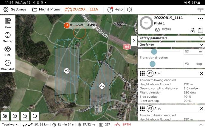
Loiter waypoints can be inserted manually by tapping the loiter waypoint button displayed in the figure above. They can be dragged and placed to a safe, collision-free point, where WingtraOne can safely loiter up or down.
Note that the entry and exit altitudes are usually linked to the areas, but when the adjacent element is not an area, it can be adjusted to suit the path planning needs.
Altitude graph
The lower part of the WingtraPilot screen features a graph that indicates the flight altitude over the entire plan. You can display the altitude graph by pressing the button on the bottom right corner in the flight plan menu of WingtraPilot. Please note that when not flying the full flight plan, e.g., in resume operation, the altitude graph does not indicate the true flight, but the full flight plan.
Red parts of the altitude graph, such as the ones in the picture below, indicate the regions where the safety of the flight plan is violated. Adjust the flight or safety parameters, i.e. min. and max. height above ground, and check again the altitude graph; otherwise, uploading the flight plan will fail. To resolve the issue try the following:
- Make sure to align the flight direction with the terrain. You might want to split an area into multiple smaller areas that you can align better with the terrain. For more information, check out our article on terrain following.
- Make sure that your flight height is higher than the minimum height above ground parameter.
- Increase the maximum height above ground parameter to resolve the conflict.
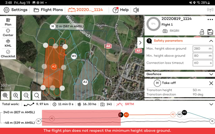
When no elevation data is available, the altitude graph cannot be used, and the Failed to load elevation data message will be displayed.
Ground elevation offset feature
In case you disable terrain following for a specific area, you can make use of the ground elevation offset feature. Without terrain following, WingtraOne will fly every area at a constant altitude. In order to account for differences in ground elevation, you can set a ground elevation offset. This is an additional offset added to the flight height.
If you take off on a hill, for example, and want to map fields that lie 50m below your home position, you can set the "ground elevation offset" for the respective area to -50m. Like that, WingtraOne will adjust its Flight Plan to achieve the desired GSD and overlaps at the specified ground level. Be aware that points that lie above your specified ground elevation value will be mapped with better (lower) GSD but with worse (lower) overlaps than set in planning.
Ground clearance checks
Your flight plan is checked for ground clearance as part of the preflight checklist. When uploading the flight plan to WingtraOne, also the takeoff and landing paths are checked.
In case the flight path of the area(s) violates the ground clearance check, you will not be able to upload the flight plan, and the takeoff will be prevented. Check the altitude graph to see where you violate ground clearance.
In case there is an uphill transition where WingtraOne is expected to be lower than 35 m to the ground, you will be warned at upload time by a safety wizard.
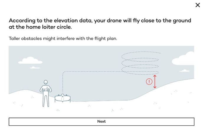
You will be guided to select the height of the obstacles in the area and based on the selected option adapt the transition height to comply with the ground clearance or continue with your planned value.
In case there is a difference higher than 15 m between the take-off altitude and the terrain elevation data, a safety wizard will warn you.
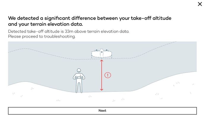
Then, a sequence of wizards will guide you through the different scenarios and options based on the environment you operate.
Elevation data and position measurements of the WingtraOne are subject to uncertainties. Also, the used elevation data does not consistently account for vegetation, buildings or other obstacles. The ultimate responsibility for sanity of the planned flight plan remains with the operator.