RGB cameras
For every flight, a folder with the project's name is created on the SD card in the "WingtraPilotProjects" folder. The collected images, GNSS data, and flight records of the corresponding mission are saved in this project folder.
In case a flight plan requires multiple flights to be completed, note that a project folder is still generated per flight.
The following subfolders are created after the flight within its project folder: DATA, IMAGES, and FLIGHT RECORDS. 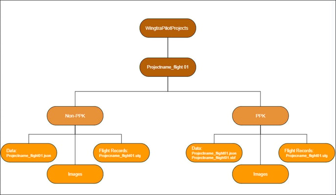
The the GNSS information for this flight is stored in the DATA folder. For WingtraOnes without a PPK module or non-PPK enabled, you'll find only the .json file with the time and GNSS coordinates and attitudes for all images. This file is used for non-PPK geotagging. When the PPK module is installed on the WingtraOne and the PPK license is activated, the DATA folder contains the .json file and the .sbf file with the GNSS information of the mission for PPK geotagging purposes.
All the images gathered in this particular flight are stored in the IMAGES folder.
Logs for preflight check and in-flight data start once the WingtraOne is powered on. After each flight, these logs are stored within the SD card and a sub-sampled set of logs are saved within the FLIGHT RECORDS folder. The flight records can be imported and visualized in fleet management platforms, as explained in the article Using flight records in AirData and Dronelogbook.
The logs stored in the Flight Records folder do not correspond to the full WingtraOne logs required for troubleshooting issues.
After geotagging
After the geotagging process is completed within WingtraHub, the OUTPUT subfolder is generated in the project folder. This folder contains all the outputs for the geotagging process. The generated outputs are contained in a .csv text file with the geotags of each one of the images and a PDF processing report that contains all the information regarding the geotagging process. The tagged images with GNSS coordinates and exact GPS time embedded as EXIF tags are also stored in the OUTPUT folder together with .csv and pdf report when the "Output geotagged images" option in WingtraHub is selected.
The processing report is divided into three sections.
- Project summary gives you basic information about the project that was processed. This information includes the project name, date and times of both flying and processing, as well as the number of images.
- Processing summary contains information about the input data used for processing. Here, you can see which base data was used, the coordinates of the base station and information about the base station antenna.
- Quality Summary shows you the most important parameters of the processing as follows:
- Matching shows you the number of images that were geotagged
- PPK fix indicates the percentage of images that were tagged using a fixed PPK solution
- Mean accuracy is the average accuracy of the projected center coordinates of all geotagged images
- Warnings indicate issues or bad results during or after processing, with detailed messages appearing in the specified box
Multispectral cameras
PPK geotagging of multispectral imagery is available only for WingtraOne GEN II drones.
The images are stored in folders (“0000SET”, “0001SET”, ...) in the camera SD card. Please ensure that you do not modify the folder or file naming structure as WingtraHub is searching for this to ensure all images are selected. The metadata, such as geolocation, is written to the EXIF of each image. Therefore, there is no need for geotagging using WingtraHub. A new folder is created each time the camera is powered on or if the maximal number of images per folder is reached (1000 images).
For every trigger event, the information from each spectral band is saved in a separate image. The 5 grayscale images represent the following 5 narrow bands: Blue (475 nm center, 20 nm bandwidth), green (560 nm center, 20 nm bandwidth), red (668 nm center, 10 nm bandwidth), red edge (717 nm center, 10 nm bandwidth), and near-IR (840 nm center, 40 nm bandwidth). For the Altum camera, there is one more image, of the thermal band, stored.
For a more detailed process on geotagging Multispectral imagery, please refer to this article, PPK geotagging of multispectral imagery.