Receiver INdependent EXchange [RINEX] files are the industry standard for GNSS data. Many GNSS receivers record raw satellite observation data in proprietary formats that can only be processed with specific software. Converting these files to RINEX allows for software-independent processing and sequential file combination if needed. RINEX version 2.x is widely used and an available output option on most GNSS receivers.
WingtraHub uses RINEX 2.11 or newer from the Base Station in the PPK geotagging process.
There are many different programs available online to convert your GNSS data from its native format to RINEX, e.g. Topcon’s TPS2RIN and Trimble’s Convert To RINEX.
While a RINEX file might still be difficult to read, the formatting is standard and some basic knowledge of RINEX structure can help determine if there were issues with the GNSS data.
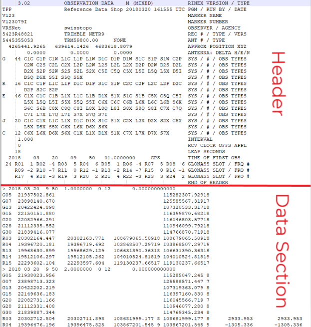
RINEX files consist of two important sections:
- the header- explaining the setup of the GNSS system and configuration of the logging file.
- data section- contains information from one site at one station and its relative distance to GNSS satellites.
RINEX file types
RINEX files will have a three-character file type name that will start with the last two digits of the year it was recorded followed by one character depicting the type of RINEX exchange file. Depending on the process or software you use to convert your data to RINEX, you may see additional output options. A truncated list from the International GNSS Service (IGS) defines the following list for RINEX exchange files:

O: Observation file (.YYo)
The Observation file provides the following three crucial measurements:
- Time: the recorded time of the GNSS receiver for the received signals expressed in GPS time
- Pseudo-range: approximate distance (m) from the satellite to the receiver including clock offsets and atmospheric delays
- Phase: number of waveforms (ß) measured since locking with the satellite including the fractional initial waveform (α) and assuming no slips (loss of lock commonly caused by power loss, an obstruction, or low signal-to-noise ratio)
N: GPS Navigation file (.YYn)
The navigation file contains broadcast ephemeris of the satellites and includes position, velocity, and clock information for the US GPS system.
G: GLONASS Navigation file (.YYg)
The navigation file contains broadcast ephemeris of the satellites and includes position, velocity, and clock information for the Russian GLONASS system.
RINEX header section formatting
RINEX headers are standardized. Some entries are optional but if configured correctly in the GPS prior to recording, you can find important information such as site name, antenna type (important for an antenna reference point), pre-processing approximate position, and time of first and last observation file in UTC time.
The time of your Wingtra flight must fall entirely in the time between the first and last observation for the geotagging process to succeed.
RINEX data section formatting
The RINEX data section records the satellite observations. You will notice this section is separated into repeating blocks that show the observations per interval, or epoch defined by the logging rate of the receiver.
The observable begins by marking the time of the epoch followed by the epoch flag*, the number of satellites per system (GPS or GLONASS), and the identifier of each satellite used in the observable.
The second section of the observable lists the parameters of each signal that provide the GPS with the amount of time each signal took to travel from the satellite to the antenna. These observations are combined and averaged over the length of the logging session to trilaterate the final position of the GPS antenna.
For a more detailed description of RINEX see IGS Formats and Standards.