The base station data recorded from a fixed position during the flight serves as a reference to calculate precise location data for each flight image.
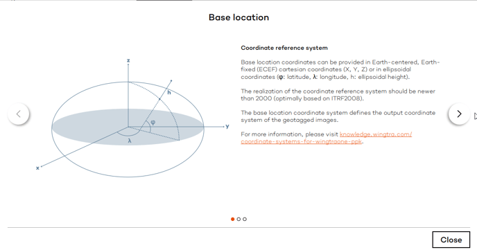
The accuracy of WingtraOne PPK data strongly depends on a proper base station setup and correct base station coordinates. For all base station options listed below, it is mandatory to use ITRF-based geodetic coordinate systems to define the base location in WingtraHub PPK processing.
Your base file options
There are different options to acquire base files and base location depending on your country, location and the surveying equipment you own. You can choose one of the four options described further below. The base files (RINEX) need to cover the full period of your flight—make sure they start before you take off and stop after you land.
Normally, you will get three files (with endings .o, .n, and .g), and WingtraHub will use all three of them. For the logging interval, we recommend a value between 1s and 10s. We recommend using WGS84 coordinates with ellipsoidal height (altitude above ellipsoid) to specify the base location. If you know your base location in local coordinates, make sure to use an exact transformation between your coordinate system and WGS84, ellipsoidal. Other Earth-fixed and Earth centered coordinate systems that are based on ITRF standards, and that use ellipsoidal height reference, may be used as well as an input coordinate system for the base location.
Please check with Wingtra support to confirm your choice as compatible, by submitting a support request.
General base station requirements
In general, most base station modules and brands combine with WingtraOne PPK. The minimum requirements for a base station are:
- Possibility of continuous logging with a logging interval of 15s or faster (1s is recommended for highest accuracy)
- Logging the following frequencies: L1C/A, L1P, L2P, L2C
- Receiving constellations GPS + GLONASS
- Possibility to save/convert logging data to RINEX files (receiver independent exchange format) with version 2.11 or newer
- The base station should be as close as possible to the survey area to ensure maximum accuracy
Low cost receivers are less reliable against GNSS signal noise, which can lead to low PPK fix and decreased geotagging accuracy. We recommend using a high-quality, survey-grade GNSS antenna.
Base station setup
The prerequisite for the base station being able to log healthy satellite signals is to have a clear sky around. When picking the right point where to set up the base station make sure to stay away from:
- Trees and high human-made objects - both will block the signals coming from satellites visible on the horizon, which could consequently lead to failure during PPK processing.
- Emitters of radio magnetic radiations (e.g. cellular towers, high voltage electrical towers, etc) - electromagnetic interference could jam the signal
Option 1: Use subscription to a CORS or VRS network
In most parts of the world there exist Continuously Operating Reference Station (CORS) networks. They consist of a number of fixed base stations, to which you can subscribe. They offer web services that let you download base files and a base location. Download RINEX files from the nearest CORS base station in your network. The base location is normally given in a local coordinate system. It is mandatory to use ITRF-based global coordinate systems with an ellipsoidal height reference. Therefore, we recommend converting the provided coordinates to WGS84 with ellipsoidal height considering the correct epoch.
Alternatively, most of the networks offer a Virtual Reference Station (VRS) option, that interpolates the correction data of several nearby CORS stations to further improve the accuracy of your project. For VRS stations the same coordinate system considerations apply.
Option 2: Use your own RTK-enabled base station
If you want to use your own RTK GNSS base station, place it in an open space when arriving at the field. Measure the base location with the device, and make sure to save the coordinates. Start logging of the base station file >10min before you take off for the first flight, and log continuously until after your last landing. Depending on the base station model, you will log the file to an SD card in the receiver or stream it to a laptop or mobile device. The raw GNSS static files from your receiver (trimble: .t00, topcon: .tps, leica: .m00, septentrio: .sbf) need to be converted to the RINEX file format.
Option 3: Use your own non-RTK base station and place it on top of a point with known coordinates
If you own a GNSS base station that is not RTK enabled, you need to provide the base location manually. This can be done by placing the base station on top of a point with known coordinates. Make sure you know the height of the pole to calculate the base location based on the known coordinates. The base location is defined at the GNSS receiver antenna center. When you get to the field, place the base station on top of the known location and start logging before the first flight takes off. Depending on the base station model, you will log to an SD card in the receiver or stream it to a laptop or mobile device. The raw GNSS static files from your receiver (trimble: .t00, topcon: .tps, leica: .m00, septentrio: .sbf) need to be converted to RINEX file format.
Be careful not to stand close to the base station during flight because it could interfere with the drone radio.
Option 4: Use your own non-RTK base station and use third-party applications to calculate the base location in retrospect
In case options 1-3 are not available and you own a GNSS base station, you have the additional option to calculate the base location in retrospect using third-party software. For this workflow, place the base station when you arrive at the field. Configure the GNSS receiver as a base station and start logging. Depending on the base station model, you will log the RINEX file to an SD card in the receiver or stream it to a laptop or mobile device. In order to get sufficiently accurate results, the static GNSS observation time should be at least one hour. At least two days after your flights, you can upload the RINEX files to an online GNSS data processing facility that uses Earth-wide orbit, clock and Earth-rotation corrections to estimate the base location in retrospect.
This method is typically used when the base length to a reference station is too long. In remote areas this is common. A longer logging duration is suggested to get a more accurate base location.
The Australian service Auspos is a widely-used third-party software that works worldwide. Upload your RINEX files at least two days after the data collection, and you will receive the base location with a detailed report via email. For Trimble users, RTX is a good tool available in TBC.