Flight time, coverage and job time with the WingtraOne
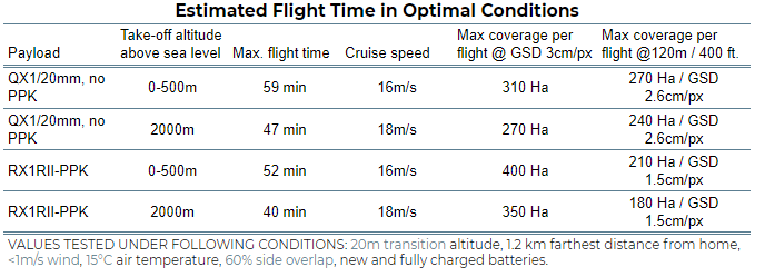
WingtraOne’s maximum tested flight time is 59 mins. However, the flight time of any drone is influenced by many factors and should not be expected to be uniform. In many cases, the coverage and job time are more important than flight time.
Factors affecting flight time
Payload
Using a heavier payload configuration reduces flight time. For example, when switching from the QX1 20MP camera, with a 20mm lens and no PPK module, to the heavy RX1 RII camera, with a PPK module, the flight time is reduced from 59 minutes to 52 minutes. However, at 3cm (1.2 in)/px GSD, the RX1 RII covers 400 ha in 52 minutes whereas the QX1 camera only covers 300 ha in 59 minutes. So even though the flight time is shorter with the RX1 RII, you get your job done faster!
Altitude above sea level
As the air gets thinner with increasing altitude above sea level, the drone flight time is reduced. However, the WingtraOne partially offsets this effect by flying faster! Note that at 3cm (1.2 in)/px GSD, the RX1RII camera with the PPK module covers 350 ha in 35 minutes at 2000m above sea level. In contrast, the QX1 camera cannot even cover this much area even when flying 59 minutes at sea level! So even though your flight time is reduced from 59 minutes to 35 minutes, you can acquire more data in that 35 minute period.
Transition height
Because the WingtraOne uses significantly more energy while hovering, the transition height affects flight time. A higher transition height will result in a reduced flight time.
Wind
In stronger winds, drones consume more energy while flying and landing, which means missions will end up with shorter flight times.
Temperature
As temperature changes air density, it also affects flight time directly. Higher temperatures mean lower flight times.
Example flight times
The tables below give you measured example flight times in optimal conditions:
- Transition altitude: 20m
- Wind speed < 1m/s
- Farthest distance from home: 1.2 km
- Air temperature: 15 °C,
- Side overlap: 60% (70% for RedEdge-MX)
- RTH mode: Direct
WingtraOne GEN II
Maximum flight time in optimal conditions
| Payload | Take off altitude AMSL | Max.flight time | Cruise speed | Max coverage at GSD 3 cm/px (1.2 in/px) |
Max coverage at 120 m / 400 ft |
| RXRII | 0-500 m | 54 min | 16 m/s 36 mph |
400 ha 990 ac |
210 ha at GSD 1.5 cm/px 520 ac at GSD 0.6 in/px |
| a6100 | 0-500 m | 54 min | 16 m/s 36 mph |
310 ha 770 ac |
240 ha at 2.4 cm/px 600 ac at 0.93 in/px |
| Oblique a6100 | 0-500 m | 49 min | 16 m/s 36 mph |
||
| RedEdge MX | 0-500 m | 59 min | 16 m/s 40 mph |
WingtraOne GEN I
Coverage
Coverage is the area that you can acquire data on in a single flight. For most applications, coverage per flight is much more important than flight time! It is influenced by resolution / flight height, sensor size and side overlap. The RX1 RII camera can cover more area at 3 cm (1.2 in)/px GSD in 35 minutes than you can cover with the QX1 camera in 59 minutes. On the other hand, if you have to fly at 120 m (400 ft), the QX1 covers more area than the RX1 RII, but it also gives you a lower 2.6 cm (1 in)/px GSD compared to the 1.5 cm (0.6 in)/px GSD of the RX1 RII. So picking the right configuration for your use case and environment is important.
The coverage is influenced by
- Flight height: The higher you fly, the more you can cover. At the same time your resolution is reduced when flying higher.
- Sensor size: A larger sensor can capture more ground with every picture taken. For this reason, you can fly higher and cover more with our RX1 RII camera.
- Side overlap: Decreasing side overlap gives you more coverage per flight. However, excessively low overlaps can result in failed map reconstruction.
Job Time
At the end of the day, it is not about flight time, but rather about how fast you can get your data acquisition done for a given area. Compared to quadcopters, a WingtraOne can acquire data up to 14x faster. Make sure you select the right camera configuration. In many cases, the right camera and settings can get your data captured faster even if the flight time might seem shorter!
