What are the smallest areas you can map?
You can map areas as small as you like. For maps that are smaller than 130 by 80 meters (430 by 260 feet) or 1 hectare (2.4 acres), like a baseball court, we recommend to setup a bigger flight plan and crop the map after processing to your desired region of interest. The additional imagery that you will capture is needed to reach accurate results in photogrammetry as we will outline further below. A flight covering 130 by 80 meters (430 by 260 feet) will take you below 3 minutes. However, because the drone has to make turns outside the area of interest that you are mapping, the drone will fly across a larger area during turns and during loitering. For this, the minimum area above which the drone is flying is always 320 by 120 meters (or 1000 by 400 feet).
You do not have to fly a certain amount of time with the WingtraOne to aquire PPK fix. The GNSS module acquires PPK fix very fast as soon as it transitions into forward flight. There is no minimum flight duration.
However, for short flights, it is important to follow the PPK recommendations carefully. For large flights, areas with low PPK accuracy can often be compensated by other areas with good PPK accuracy during postprocessing. As for short flights, this might not be possible, a good base station setup is crucial.
Example: Mapping a baseball court
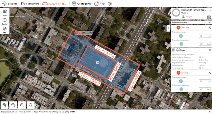
Flight time: 2min 47 seconds
Total area mapped: 1.0 hectares / 2.4 acres
# of images: 45
Width of flight manoeuvres: 120m / 400 ft
Length of flight manoeuvres: 320m / 1000 ft
Minimum number of images for post-processing
Make sure to check with your photogrammetry software provider, what the minimum number of images is that they need to successfully create a map.
For a successful map, we found that 45 images or more are recommended to converge to survey-grade absolute accuracy. With a smaller number of images, camera intrinsics are typically not estimated to the precise values leading to reduced accuracy in the final map output. Therefore, we recommend to include at least 3 flight lines with 15 images per flight line (or 5 flight lines with 9 images per flight line).
Flight time
If you want to map several small areas close by, it is recommended to cover them in one single flight plan using multiple areas. You will be able to cover the areas more efficiently compared to multiple flights with takeoff and landing in between the flights. This way you will also need less battery, as forward flight is 4 times less power consuming compared to vertical flight mode.