What is Geo-Awareness?
To keep aircraft and people on the ground safe, UAS Geographical Zones (UGZ), or short geo zones, have been set up across Europe by the different states. Geo zones are portions of airspace where drones, or to use the more official term Unmanned Aerial System (UAS), operations are facilitated, restricted or excluded. Geo zones are set up to:
- minimise safety risks
- protect the privacy of others
- address security issues
- deal with environmental concerns
“Geo-awareness” means a feature that allows the user to be aware of these geo zones when planning and conducting flights in the open category in an EASA member state.
How do I know if can fly in a location?
All EASA member states are required to publish maps identifying geographical zones where all drone flights are forbidden or where you need to have a flight authorisation before starting the operation. In most states, apps for mobile phones are available to identify where you can fly easily.
On the EASA website, you will find links to national restrictions from each national aviation authority.
In some member states, you can download the geo-zones directly as a .kml or in other file format that can be converted to .kml. In others, you will only be able to display the geo-zones online. In these cases, you can create your own .kml file and upload it to WingtraPilot.
- Switzerland:
- https://data.geo.admin.ch/browser/index.html#/collections/ch.bazl.einschraenkungen-drohnen/items/einschraenkungen-drohnen?.language=en
- Allows download of .json, .shp or .geojson format
- Belgium:
- https://apps.geocortex.com/webviewer/?app=1062438763fd493699b4857b9872c6c4&locale=en
- Allows download of .json file
- Cyprus:
- Denmark:
- https://www.droneregler.dk/dronezoner/data-til-download
- Allows download of .kml and .geojson files
- Finland:
- https://www.droneinfo.fi/en/news/uas-geographical-zones-machine-readable-format
- Allows download of .csv file
- Ireland:
- https://www.iaa.ie/general-aviation/drones/docs-list/docs/default-source/publications/aeronautical-notices/u---unmanned-aircraft/uas-geographical-zones
- Table with all UGZ can be downloaded as .pdf file
- Romania:
- https://flightplan.romatsa.ro/init/drones
- Allows download of .xlsx, .json or .shp files
- Spain:
- https://drones.enaire.es/
- Allows export to .geojson and .csv files
- Sweden:
- https://daim.lfv.se/geoserver/web/wicket/bookmarkable/org.geoserver.web.demo.MapPreviewPage?0&filter=false
- Allows download of .kml file
- Portugal:
- https://uas.anac.pt/registry/explore
- Allows export to .kml and .json files
Note that the restrictions change frequently, and downloaded files might not contain the latest status. Always check the latest status online.
Uploading geo zones to the flight plan
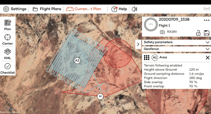
WingtraPilot provides the functionality to upload geo zones to the flight plan, in order to respect restrictions during flight planning. By displaying potential points of conflicts with the UGZ and your flight plan, it is ensured that you have an awareness of geographical restrictions pre-flight and in-flight.
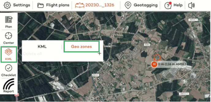
The geo zones can be uploaded as .kml files in the geo zone upload section. To do this, set a home location in the flight planning section (if no home location is defined the .kml upload will fail and WingtraPilot will display an error message). To navigate to the upload section, select “KML” from the tabs on the left side and select “Geo zones” as illustrated in the picture below.
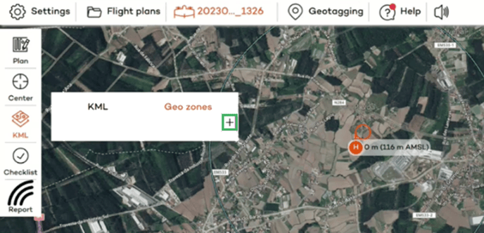
Click on the “+” sign to upload a .kml file containing geo-zones.
When the file is uploaded, the geographical polygonal shape and the name of the geo zone will be displayed, like in the example of Portugal below.
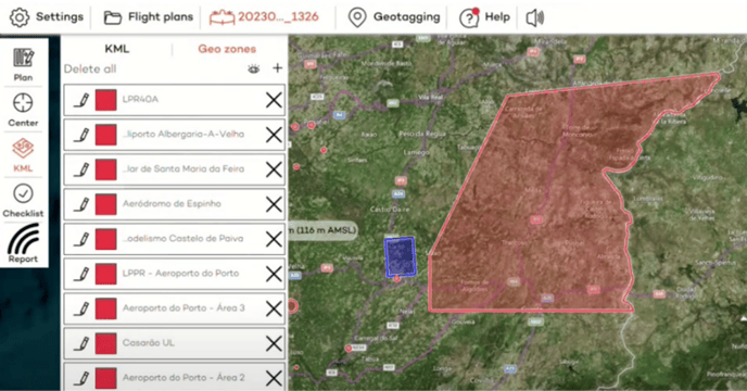
If the colour is specified within the .kml file, WingtraPilot will take over the colour defined in the .kml. If no colour is specified in the .kml, the geo zones are displayed with a warning red colour as default.
The geo zones have now been uploaded to your flight plan and will be saved as part of the flight plan. When a geo zone is selected from the list by clicking on it once, it will be highlighted on the map.
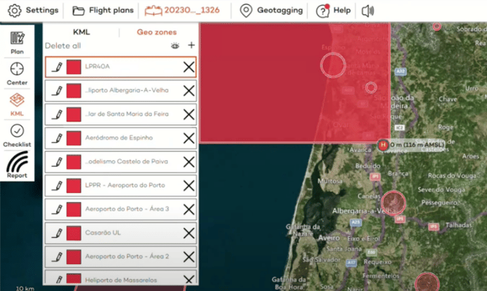
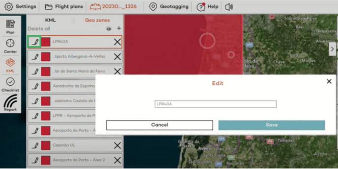
By clicking on the pencil icon in front of each zone, you can edit the displayed name of the zone. This can be used to manually add further information.
By clicking on the eye symbol you can toggle the display of the geo zones. However, the zones will always appear during the review of the flight plan during the pre-flight check and will always be displayed in-flight.

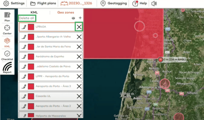
You can delete the uploaded zones if you have uploaded the wrong file. You have the option to “Delete all” or delete individual zones by clicking on the “X” symbol right to the name of the zone.
Representation of geo zones and warnings within WingtraPilot
Geo zones are represented in WingtraPilot in the following format:
- Horizontal restrictions: The horizontal restrictions can be loaded into WingtraPilot from the .kml file
- Height Limit: The UGZ vertical limits are defined from ground to 5000 meters (AMSL) for every UGZ.
- Time window: The time restriction of the UGZ has not been considered for the display. It’s the operator's responsibility to check the accuracy of the data.
Warnings are displayed in the following situations:
- In case the upload of the .kml fails (due to wrong or corrupted file format)
- The uploaded geo zones as well as the planned flight areas are displayed on the map pre-flight and in-flight. If the flight lines (blue lines) overlap with a geo zone (redzone) this depicts a potential breach of a geo zone.