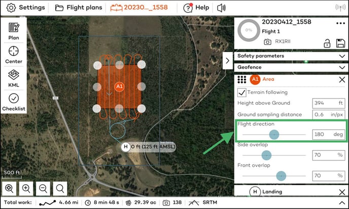
Choosing the most appropriate flight direction involves considering different parameters. The four key factors to consider in order of importance are terrain following, wind direction, picture efficiency, and polygon shape. To change the flight direction, use the slider, or to be more precise click on the box to type the exact degree.
Ground Clearance
The most important thing you need to consider when choosing the flight direction is ground clearance. We recommend flying perpendicular to the slope like a switchback rather than in its direction. Don't fly straight into the slope! A waveform of the ground elevation in the altitude graph indicates the latter, while a flat ground with steps at the turnarounds would be ideal. Also consider enough space for the turns so that they do not interfere with any objects close by.
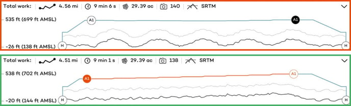
WARNING! It is not safe to fly with large humps in the graph, because this indicates that you are flying in the wrong direction! The path will show in red if there are portions below your minimum ground above height. Above you see the graph image on top, showing the wrong way, versus the bottom ideal path.
Terrain following
The second important thing to consider when choosing the flight direction is the terrain following. This tool is used to maintain the distance between the drone and the terrain, and thus, having a constant resolution throughout the map. If the map is outdated and does not correspond to the terrain (this can happen in mining, road construction, or even ports), you can upload your own DEM into WintraPilot to have a more precise map: Custom Elevation Data Import
Wind direction
In case of notable wind, we strongly advise you to fly orthogonally to the wind direction. Try to avoid strong tailwinds and headwinds to avoid missing images. To improve output reconstruction, especially for homogeneous areas, it is not recommended to fly aligned with linear structures (such as roads or cultivated fields). This reduces the number of similar-looking images.
Note: When planning a mission in conditions with high winds, we recommend considering the drone in the midst of turns. To learn more about this, please read Flying in windy conditions
Picture efficiency
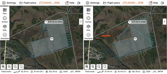
In order to create a good map, it is important to choose the correct overlap. You always want to fly slightly more than the defined area to get enough overlap on the edge of the polygon. Be cautious: if the mission has sweeps outside the drawn polygon, the drone will take pictures throughout the entire sweep, wasting both flight and post-processing time capturing pictures of an undesired area. By changing th flight direction or splitting the areas up, we can reduce unnecessary images.
Polygon shape
When drawing polygons or importing KML files, flying parallel to the longest edge decreases the number of turns, which leads to longer flight duration. With this strategy, the maximal coverage can be reached. For example, when planning a corridor, try to fly the long way to reduce turns, but first take into consideration the elevation change. If there is heavy elevation change, you will need to break the corridor up into chunks or fly perpendicular. Safety clearances are more important than covering more area.