WingtraApp & WingtraCloud v1.59.0: 13/07/26
Updated file is available in shared drive
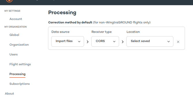
New Feature
- Default correction method in a new “Processing Settings” page
- The user can now define which correction method be the default when performing processing (map processing and geotagging). In the processing view, the correction metho can also be changed.
- For WingtraGROUND datasets, the default correction method is always WingtraGROUND - regardless of the default correction method set
WingtraApp & WingtraCloud v1.57.0: 29/06/26
Updated file is available in shared drive
New Feature
- Added telemetry rebinding support.
Improvements
- Improved guidance for compatibility updates.
- Smoother and more consistent Pre flight checklist
- Improved dataset initialization when overwriting existing datasets
WingtraApp & WingtraCloud v1.56.0: 22/06/26
Updated file is available in shared drive
Improvements:
-
Improved the accuracy of storage usage reporting during processing.
-
Expanded support for importing orthomosaic datasets.
-
Improved pre-flight SD card storage validation.
WingtraApp & WingtraCloud v1.55.0: 16/06/26
Updated file is available in shared drive
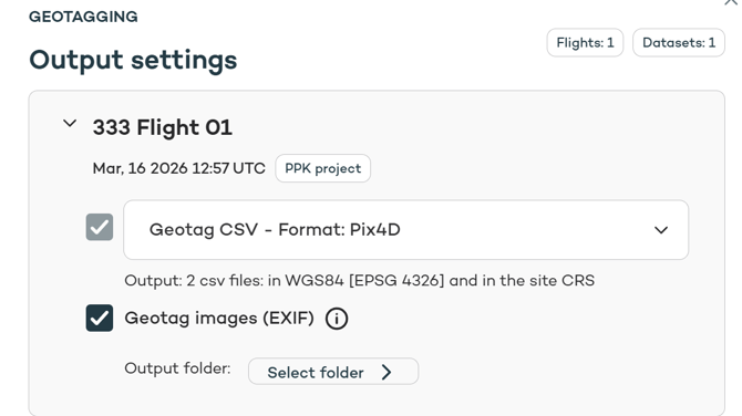
New Features:
- Local EXIF Geotagging.
Customers can now geotag image EXIF metadata in WGS84 directly within WingtraCloud without uploading the images to the Cloud.
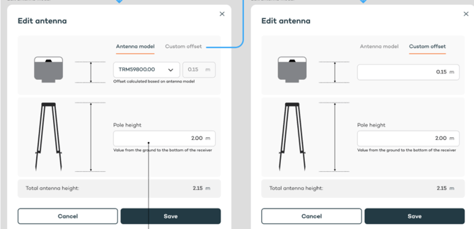
- Updated antenna editor layout with split pole height and antenna offset controls for clearer visualization
WingtraApp & WingtraCloud v1.54.0: 08/06/26
Updated file is available in shared drive
Improvements:
- Improved reliability of the Pre-Flight Checklist
WingtraApp & WingtraCloud v1.53.0: 28/05/26
Updated file is available in shared drive
Improvements:
- Enhanced control over GSD colorization thresholds during flight planning
- Clearer pre flight checklist warnings for non-default camera settings on SURVEY61
- Improved stability during drone updates
WingtraApp & WingtraCloud v1.52.0: 19/05/26
Updated file is available in shared drive
Improvements:
- Clearer error messaging for failed projects
- Shared flight plans now include payload information
WingtraApp & WingtraCloud v1.51.0: 05/05/26
Updated file is available in shared drive
Improvements:
- Fixed an issue where imported terrain could be unintentionally downscaled, ensuring DSMs retain their full resolution.
- You can now import Digital Surface Models without a vertical coordinate system , with full support for ellipsoidal height.
- Payload disconnections are now accurately reflected in the Pre Flight Check-list removing misleading messages.
WingtraApp & WingtraCloud v1.50.1: 28/04/26
Updated file is available in shared drive
Improvements:
- Shared flight plans now include payload information
- Improved reliability of processing jobs with automatic restart for stalled tasks
- Improved reliability of resume flights after app crashes / restarts during flight
- Improved visibility of the base icon during site creation across all steps
- Improved flight plan export handling from browser on tablet
WingtraApp & WingtraCloud v1.49.0: 20/04/26
Updated file is available in shared drive
Improvements:
-
Improved the UX for local storage mode to help prevent accidental activation (this mode disables browser access)
-
Moved the Local storage mode toggle to the tablet only; it is no longer available in the browser
WingtraApp & WingtraCloud v1.48.0: 13/04/26
Updated file is available in shared drive
Improvements:
- Updated warning highlighting that flying with outdated software or firmware may void the warranty
- Improved reliability of merging datasets
- Improved visibility of subscription limit notifications across main pages
WingtraApp & WingtraCloud v1.47: 07/04/26
Updated file is available in shared drive
Improvements:
- Internal improvements for increased system stability
WingtraApp & WingtraCloud v1.46 : 30/03/26
Updated file is available in shared drive
New Features:
- Geotagged images are now available for download also for merged datasets
- Orthophotos can now be imported independently as custom background maps for flight planning, without requiring a DSM.
Improvements:
- Improved handling of tablet location detection to improve Remote ID location identification
- Improved reliability when downloading large map exports
WingtraApp & WingtraCloud v1.45 : 23/03/26
Updated file is available in shared drive
Improvements:
- Enhanced file sharing for merged datasets
WingtraApp & WingtraCloud v1.44 : 17/03/26
Updated file is available in shared drive
New Feature:
- Converting layer (kml, dxf, geojson) to flight area, corridor or geobarrier
Improvements:
- Improved speed of app-drone connection
- Redesigned pre-flight checklist user interface
WingtraApp & WingtraCloud v1.43 : 10/03/26
Updated file is available in shared drive
Improvements:
- Geotagging is no longer limited to 10,000 images.
- Increased the maximum size for importing layers. The maximum size for kml/dxf is now 200MB and 600MB for geojson.
WingtraApp & WingtraCloud v1.42 : 02/03/26
Updated file is available in shared drive
Improvements:
- Introduced user interface controls for turning RE-P and LiDAR WiFi on and off
- Improved feature education: display a dedicated, feature-specific slide when a user taps on some specific PRO features.
WingtraApp & WingtraCloud v1.41.1 : 23/02/2026
Updated file is available in shared drive
Improvements:
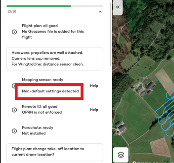
- Implemented a warning indicator in the pre-flight checklist if exposure compensation is configured to a non-default value for SURVEY61.
- Improved reliability of merged datasets
- Improved clarity and reliability of the Pre Flight Checklist, especially when having an incompatible firmware version.
WingtraApp & WingtraCloud v1.40.0: 16/02/2026
Updated file is available in shared drive
New Features:
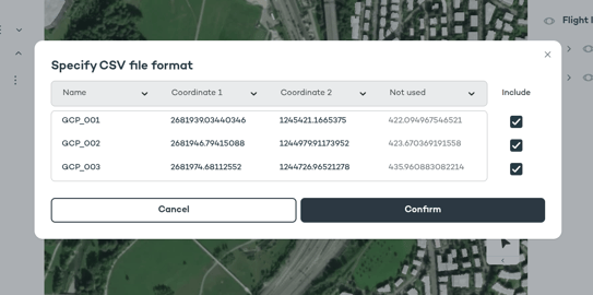
-
New CSV import interface: the user can now include and exclude rows and columns to handle a wider range of .csv files. It is also possible to change the order of the columns. The feature has been enabled across all sections that support CSV file imports.
-
A checkpoints .csv file is now generated even for maps processed without WingtraGround. For all PPK-processed datasets that include a base station, ground control points, or checkpoints, a .csv file is available on the Files page.
Improvements:
-
Improved the robustness of update operations.
-
A warning status is now displayed if telemetry is disconnected during flight.
-
Fixed an issue where the Terrain Inspector displayed an incorrect height.
-
Flight plans now display the specific drone used during the flight
Wingtra App & WingtraCloud v1.39 : 10/02/26
Updated file is available in shared drive
New Features :
- In beta: Trimble TO2/TO4 files are now supported as base/cors files for geotagging and map processing
Improvements :
- Base and checkpoints without a fix are now added to the csv
- User can now add both folders and files in the processing flow
- Strengthened the reliability of map processing workflows
- Resolved an issue where "Reuse correction data" caused datasets to not be PPK processed
- Resolved an issue where a resumed flight could open without any flight items.
- Fixed a processing issue that caused merged datasets containing four or more datasets to stall.
- Fix for resumed flight processing UI: It is now considered to be a part of the same flight
- Resolved an issue where resumed uploads were not PPK processed