
| Last Updated | September 7, 2026 |
| Products | WingtraRAY · Wingtra Software · RGB Payloads |
| Plans | PRO · UNLIMITED |
ON THIS PAGE
- Overview
- What you'll achieve
- How it works
- Before you begin
- The workflow
- Achievable accuracy
- Limitations
- FAQ
Overview
Getting high-accuracy geotags from a flight normally means using a base station in the field or downloading CORS data and processing it. Both add hardware dependencies and limitations, and both fail when a base is left behind, a battery dies, or no reference station is within range.
Network Corrections removes that dependency: our software corrects the geotags from your flight automatically, using a worldwide Global Navigation Satellite System (GNSS) correction network, with no base station or CORS data required.
What this means:
- Never re-fly a site because of a base station failure

- Get 100% coverage to unlock remote and fast-deploy projects
- Skip the base-station setup, run faster and simpler surveys
What you'll achieve
Corrected geotags for every image in your flight, with a per-image accuracy estimate — ready to use as input for map processing.
You upload only your flight data; Wingtra's software applies the GNSS corrections and returns a corrected CSVor EXIF geotags, plus a correction report on the files page.
How it works?
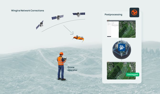
Your WingtraRAY records raw GNSS data throughout the flight, exactly as it does for any mission. When you upload the flight and select Network Corrections, WingtraCLOUD sends the flight's GNSS observations to a global correction network, retrieves the correction data, and computes a corrected position for each image geotag — you do not upload any base station or CORS files.
Before you begin
To be able to use Network Corrections, make sure you have:
- Wingtra software account on PRO or UNLIMITED plans
- Software version of v1.67 or newer
- Firmware version of v2.22.5 or newer
- Flight of at least 10+ minutes (recommended for convergence on accurate results)
IMPORTANT - Wingtra Hub Geotagging
This update introduced a regression where the drone RINEX data is automatically detected as the GNSS base data for geotagging. Geotagging is still possible by deselecting the drone data and manually selecting the GNSS base data. Better is to update to the latest Wingtra Hub release where this is fixed -> Download
The Workflow
TL;DR
Fly your project as usual, no need for GNSS data retrieval and select Network Corrections at the geotagging Corrections step for "Data Source"
Full Workflow
Step 0) - Update your software and firmware to the latest versions
Step 1) - Flight planning -> Same as before
Step 2) - Flying -> Same as before (just without a base)
Step 3) - Geotagging -> Drag your project folder in and simply select Network Corrections
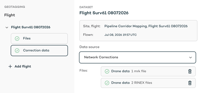 Geotag Processing Screen
Step 4) - Download / save Geotags -> Same as before
Step 5) - Photogrammetric Processing -> Same as before
All that's changed is the necessity to collect GNSS RINEX/.t0X files from a base receiver or CORS network.
For more information on the geotagging workflows and steps, see here:
Wingtra Geotagging
Achievable Map Accuracy
The following is based on testing performed in the US and Switzerland:
< 0.1 USft (3cm) Hz + V -> With GCPs
PRELIMINARY*
< 0.15 USft (4.5cm) Hz and <0.3 USft (9cm) -> Without GCPs
*Accuracy without GCPs depends greatly on coordinate system transformation accuracy, GNSS corrections, IMU data and other factors which would be mitigated largely in the map processing with good GCPs. Further testing and work is ongoing to improve and validate the achievable accuracy. This preliminary value is to serve as indicative.
Known Limitations
Supported software and firmware versions ->
Software: v1.67 or newer
Firmware: v2.22.5 or newer
Supported Drones -> Currently only WingtraRAY (GenII supported coming soon)
Payloads-> RGB payloadsfor the RAY supported (RE-P coming later). LIDAR not supported.
Published Coordinate Systems->Only tested in Switzerland and United States common coordinatesystems. Achievable accuracy in other regions and coordinate systemscould vary
Custom Coordinate Systems -> Not yet supported
Minimum Flight Duration (recommended 10-15mins) -> GNSS corrections require minimum flight time for Network Corrections to converge onto an accurate solution. Particularly in the vertical direction (e.g. troposphere + ionosphere modelling). This is likely to manifest as a vertical offset in the final map.
Wingtra Hub Regression -> Due to RINEX files being created, Wingtra Hub incorrectly identifies the drone data in the project as the base data in it's auto scan. Deselection and reselection of the correct data is possible. This is fixed in the latest Wingtra Hub release - Download Link
FAQ
Q: Do I need to record from a base station or pull data from a CORS to use?
A: No -> Network Corrections just the needs the navigation
Q: Do I need internet to geotag with Network Corrections?
A: Yes -> Navigation data is sent to Trimble's PP-RTX service for GNSS correction
Q: Is my sensitive image data sent to another online server / web service to process?
A: For pure geotagging, no.
Q: What is the minimum flight time required?
A: Recommended flight duration is around 10-15 minutes (FAST regions defined by Trimble's PP-RTX as USA, Brazil and Europe use regional modelling and faster convergence times - this leads to reduced flight time)
Q: Is there any usage costs or limitations?
A: No - Network Corrections is included in all PRO and UNLIMITED plans without usage limitations
Q: What errors am I likely to see if I don't use GCPs?
A: Based on initial testing, the error mostly results in a vertical offset. Horizontal errors on geotag locations and orientations are largely mitigated due to high overlap. The relative geometry of the model (with RAY + SURVEY61) has been shown to be good that an alignment to a previous 3D map may be possible (e.g. C2C registration).