
What is MAP61?
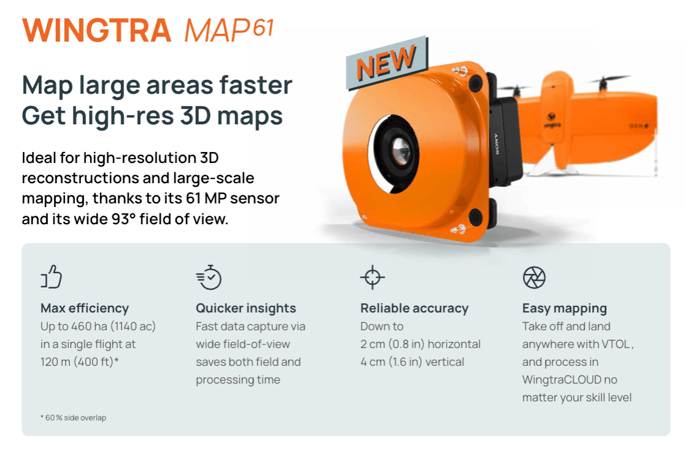
MAP61 is our newest mapping camera, that features best productivity across our camera portfolio (map 40% more than RGB61 at the same flight height) and enables stunning 3D results thanks to it's wide-field of view with a forwarded-tilted mount.
Who is MAP61 for (and who not)?
MAP61 is the desired choice for everyone who cares most about productivity or 3D results (pointclouds, meshes). For people that want the tightest resolution and accuracy ("survey-grade"), RGB61 stays to be the best solution.
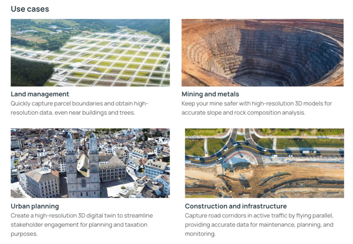
Overview on MAP61 use cases:
Deep dive on MAP61 use cases:
- Land management & urban planning
- Cadaster / land use monitoring: Aerial insights help local authorities monitor land use, identify property boundaries encroachments, enforce proper taxing, and settle legal arguments by showing whether land use is according to the law or current contracts. This is typically done based on the true Orthomosaic. A resolution of 3-5 cm/px is typically enough for this use case which makes the MAP61 the perfect tool because of it's impressive productivity (dataset coming soon)
-
- Cadaster / building tax management: Aerial insights help local authorities to monitor whether buildings are built according to plan and adjust taxing accordingly. A good 3D map, typically a mesh, is required for this purpose which makes the MAP61 the perfect tool because of it's great 3D capabilities paired with the best productivity. MAP61 example dataset of Zurich (Wingtra dataset)
-
- Digital twin (city, town): The reality data coming from drones is an essential layer in an urban digital twin. The digital twin as a whole enables a more efficient city management and communication across stakeholders. To name a few specific examples: Simulation of urban developments through building overlay and vegetation growth simulations, infrastructure monitoring e.g. on parking lots, wayfinding in 3D, tree management, facility management, environmental analysis, participative processes, etc. MAP61 example dataset of Zurich (Wingtra dataset) // Video of ESRI based on previous Oblique Sony a6100 Zurich dataset.
- Golf course management: Course ratings done by the association are now based on aerial data instead of terrestrial. Re-construction planning with optimised cut & fill and green maintenance are additional benefits of the data. The MAP61 offers not only unparallel efficiency for these large scale map and hence optimises the margin of the service provider, it also improves the 3D result which is needed for the rating. MAP61 example dataset of Golf Course Moossee (Pixmap, Swiss customer)
- Forest management & wild fire prevention: For firefighters, the Orthomosiac, 3D model, and multispectral map provide critical information for planning and responding to fires, ensuring better situational awareness, coordination, and post-fire recovery. For foresters, the aerial insights are essential tools for monitoring forest health, managing land use, and ensuring sustainable and effective forest operations. MAP61 example dataset of Winacka Forest in California (KRS, US customer)
- Mining
- Pit progress review: By regularly monitoring active pushbacks, engineers can provide better excavation designs and optimise the yield of a pit. The WingtraOne with the MAP61 enables you to do this regular surveys with takeoff outside the pit while covering not only one but multiple active pushbacks in a single flight. The reduce data volume enables fast processing such that the engineer has the insights at his fingertips within hours. (dataset coming soon)
-
- Highwall stability assessment: Collapsing highwalls pose a critical safety risk in mines and have an additional big economic impact if valuable ore gets unaccessible. The image quality and oblique configuration of the MAP61 enable superior 3D reconstructions of steep faces even if exposed to light differences with direct sunlight and faces in shadow. (dataset coming soon)
- Construction & infrastructure
- Highway mapping without stopping traffic: Regulations in the US and other countries prohibit flying over active traffic. The wide field-of-view of the MAP61 enables this use case as the drone can fly far off the lanes still capturing the road itself in high resolution. (dataset from Alabama DoT coming soon)
- Building or infrastructure construction in urban setting: Construction projects that are situated in urban settings, i.e. closeby building, benefit from the 3D reconstruction closeby the building walls including below rooftops. MAP61 example dataset of Zurich (Wingtra dataset)
- Digital twin (industrial complex): Modern industrial complexes from ports over chemical plants to railway stations are working with a digital twin to coordinate reconstruction planning. The reality layer, typically a high quality 3D mesh, is typically coming from a high-quality drone survey and the resolution of the MAP61 provides superior quality for this reality layer. MAP61 example dataset of Olten Railway Station (Wingtra dataset)
Ideal customer profile:
- Strong need for one of the following:
- 3D mapping need
- Pit/highwall in mining
- Buildings, towns, suburbs, villages
- Construction sites in urban settings
- Legal constraints not to fly over traffic (highways US)
- Productivity: projects are regularly bigger than 500 ha (1’000 acres)
- 3D mapping need
- Region: Global
- Company size: Any
- Industries: Land management & urban planning, mining, construction, others
Timeline
- August 2024: MAP61 is for our partners available for purchase since Aug 23, 2024 (SKU: MAP61-ADD-GEN2)
- September 2024: Public launch is on September 24 (with Intergeo)
- October 2024: Series shipping starts first week of October
Pricing & Launch Promotion
You can find the SKU (MAP61-ADD-GEN2) in hubspot and in the partner portal, please refer to there for up-to-date pricing in your currency- MSRP: USD 11'500
- Partner discount: 20%
- Partner price: USD 9'200
- Special partner launch promo price: USD 8'000*
*valid until November 30 EOB, 2024
FAQ
What are the technical specifications?
See MAP61 one-pager (2nd page)
When should I sell MAP61, when RGB61?
See above, "who is MAP61 for (and who not)?"
When should I sell MAP61, when Oblique Sony a6100?
If you can afford it, you should purchase MAP61. It features better performance in all dimensions (image quality, resolution, productivity, etc) but comes at a higher cost.
Does Wingtra offer a Trade-in program for Oblique Sony a6100 or RGB61?
We do not have global promotions for trade-ins or upgrade paths. The only global promotion is the launch promotion (see above). We welcome you to discuss local sales tactics with your RSM to win additional deals.
What are the EUR prices?
Please visit the hubspot catalog. The special partner launch promo price is EUR 7'200.
What is the competitive advantage over WingtraOne GEN II Oblique Sony a6100?
The MAP61 brings a higher quality and higher resolution camera than the 24 MP Oblique Sony a6100. Furthermore, the field-of-view is also slightly increased. This means that you can get
- A better and 30% higher resolution 3D map if you map at the same flight height. If you fly e.g. on 120 m AGL, you map with a GSD of 2.7 cm/px (MAP61) instead of 3.9 cm/px (Oblique Sony a6100). The better sensor and optics add additionally to the quality of the model.
- A 190% better coverage if you map at the same resolution. If you fly e.g. with a GSD of 2.0 cm/px, you map 350 ha (MAP61) instead of 120 ha (Oblique Sony a6100).
What is the competitive advantage over DJI P1?
The WingtraOne GEN II with MAP61 and WingtraCloud shines along the following dimensions:
- Easy to use end-to-end workflow from planning to results in a single ecosystem that is tailor-made for mapping & surveying
- Superior image quality with 61 MP
- Significantly faster in the field and in processing which improves your margins and allows you to take on more projects
Will Wingtra offer different lenses for the MAP61, e.g. 24 mm or 35 mm?
The short answer is "no": MAP61's camera, lens and mount combination has been chosen as it provides the best solution for large-scale mapping as well as best 3D reconstructions. The combination enables similar field-of-view to the 'front' as to the 'sides' (~50 degrees off-nadir), which is required for best 3D modelling without the need for flying cross-hatch patterns. If you require highest resolution for your projects, take a look at the RGB61, which is featuring a 24mm lens in a nadir configuration.