In this document
- WingtraLIDAR Ressources
- Recommended flight settings and recipes
- Competitor comparison
- DJI M400 L3
- Freefly Astro/Alta X
- Inspired Flight
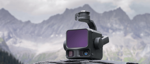
📚 WingtraLIDAR ressources
💡Pro tip: Please familiarize yourself with these documents, they help at all stages of the sales process.
Product Webpage
Pitch Deck (to present to partners and customers)
Dataset Library (show customers what data output we produce)
Operator Training course (Preparing, flying and post-processing)
LiDAR Demo Checklist (Preparing onsite LiDAR demos)
📋 Demo Checklist
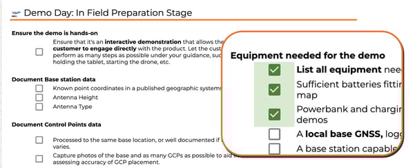
Open LiDAR Demo Checklist
This tool serves as a tool for planning and executing LiDAR demos for potential customers. It is designed to ensure that every stage of the demonstration process—from initial planning to closing the sale—is handled professionally and consistently.
The document is organized into several key areas:
-
- Planning & Preparation: Tasks to complete before the demo
- Demo Day: Field-specific steps for data capture
- Post-Processing & Debriefing: Steps for data retrieval and follow-up meetings with the customer.
- Success Criteria Checklist: Documenting the customer's specific problems and the "success criteria" they need to see confirmed to make a purchase decision.
⚙️ Recommended flight settings and recipes
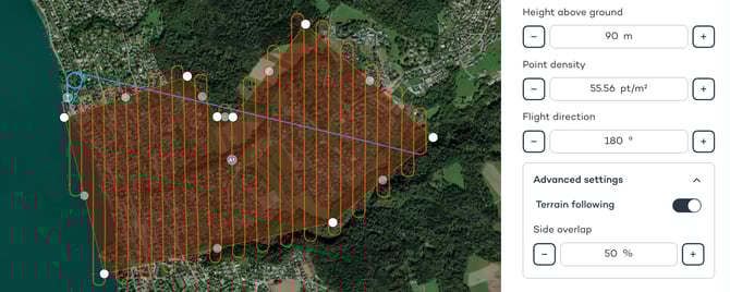
💡 Depending on your use case -> flight height, side overlap and flight direction are most critical to set.
Height above ground
🧱 Flying bare earth /volumetrics ? Start at 90m AGL, but don't exceed 120m AGL
🌴 Vegetated topographic surveys? Fly around 60-90m AGL
🗻 Steep terrain? Try to not exceed 80m AGL
Side Overlap
🏖️ No vegetation, flying bare earth /volumetrics ? 30% side overlap is sufficient, but we recommend 50% side overlap to be on the save site (especially for demos).
🏡 low to high vegetation for topographic surveys? 50% sidelap is the sweet spot
🌴 Dense vegetation (e.g. virgin forest)? We recommend 70% overlap.
🗻 Steep terrain? ensure 80% side overlap
Flight direction
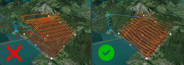
⛰️ In steep terrain, fly perpendicular to the terrain contour
💨 Wind: fly perpendicular to wind and avoid high tailwinds
Examples / Recipes
Recipe #1 - Volumetrics, flat, no vegetation -> 100m AGL, 50% side overlap
Recipe #2 - Topographic survey, vegetated area, hilly environment -> 80m AGL, 70% side overlap
Recipe #3 - Topographic survey, highly vegetated, very steep terrain -> 80m AGL, 80% side overlap
Recipe #4 - Plantation, highly vegetated, hilly environment -> 80m AGL, 70% side overlap
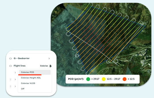
💡 Pro tip: Use WingtraCLOUD for flight planning. During planning check your point cloud density (PCD) with colorized flight lines.
⚖️ Competitor comparison
DJI M400 - L3
💡 In short:Play the strengths of the entire Wingtra platform, don't compare on technical specs or price. We are leading in overall efficiency and workflow simplicity.
🚀 Our competitive edge
-
-
Operations over people: In the US, this allows for operations over people, traffic, and populated areas (excl. open air assemblies) under Part 107 (Cat 3 OOP) - without the need to go through a waiver process.
-> DJI M400 is not granted operations over people and needs waiver process.
- Parachute: The parachute add-on removes the ground risk of the drone operation. In most countries (Africa, Asia, Australia, Latin America, Middle East, this enables advanced operating scenarios like flying over urban areas. Parachute Article
-> DJI M400 only offers 3rd party parachutes, requiring manual certification work. - C6 Certification : Easier regulatory path for BVLOS operations in Europe and EASA member states.
-> less approval friction, more scalable operations.
-> DJI M400 only provides C3 certification - Ease of Use: Strong focus on ease of use to streamline the transition from planning, capturing, processing, to final deliverables.
-> Smoother operations, less manual errors, easy to scale drone program
-
❌ Things to avoid
-
- Comparing tech specs of the LiDAR
- Comparing price of payloads
- Comparing efficiency of the payload (M400 flies around 46 minutes)
- Comparing End-to-End workflows
Download the "WingtraLiDAR vs DJI L3" Battlecard (coming soon)
Freefly
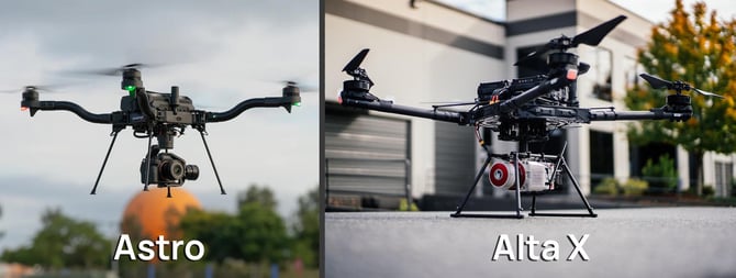
💡 In short: Wingtra dominates large-area, efficiency-driven, survey-grade LiDAR. Freefly dominates versatility, GPS-denied environments, vertical structures and high density LiDAR mapping. Play the strengths of the entire Wingtra platform, especially the turnkey survey workflow, which can be up to 60% more efficient across the workflow.
🚀 Our competitive edge
-
-
Area coverage — more efficiency by a wide margin This is the most decisive advantage. WingtraRAY can cover up to 550 ha in a single flight. The Freefly Astro maxes out around 30–60 ha per flight, and the Alta X around 60–80 ha (30mins flight time). Freefly's platforms are optimized for compact industrial work, not wide-area coverage missions.
-> Wingtra typically cuts field time by about half and reduces re-flights. - No LiDAR sensor selection complexity With Freefly, you must evaluate, purchase, and manage the right LiDAR payload. Wingtra offers a fully integrated LiDAR sensor. This matters for organizations building repeatable survey programs without dedicated sensor integration engineers. Freefly offers hardware from two or three separate companies (Freefly + YellowScan + surveying equipment), managing separate firmware stacks, and troubleshooting cross-vendor issues in the field.
-
Operations over people: In the US, this allows for operations over people, traffic, and populated areas (excl. open air assemblies) under Part 107 (Cat 3 OOP) - without the need to go through a waiver process.
-> Freefly doesn't provide compliance under Part 107 (Cat 3 OOP)
- Parachute: The parachute add-on removes the ground risk of the drone operation. In most countries (Africa, Asia, Australia, Latin America, Middle East, this enables advanced operating scenarios like flying over urban areas. Parachute Article
-> Freefly only offers a 3rd party parachute, requiring manual certification work. - C6 Certification : Easier regulatory path for BVLOS operations in Europe and EASA member states.
-> less approval friction, more scalable operations.
-> Freefly falls under the'Specific' Category - Ease of Use: Strong focus on ease of use to streamline the transition from planning, capturing, processing, to final deliverables.
-> Smoother operations, less manual errors, easy to scale drone program
-
❌ Things to avoid
-
- Comparing tech specs of the LiDAR. Freefly offers a wide range of entry-level to high density LiDARs (YellowScan, Geocue, Riegl, Phoenix LiDAR, and RockRobotics).
- Comparing price just for the hardware (Rather look at the entire approval, flight and processing process).
- Comparing on NDAA/Blue/Green level (They're built in the US with compliance in mind)
Download the "WingtraLiDAR vs Freefly" Battlecard (coming soon)
Inspired Flight

💡 In short: Wingtra dominates large-area, efficiency-driven, survey-grade LiDAR. Wingtra is ahed with it's entire fully-integrated and end-to-end workflow, which can be up to 70% more efficient across the entire workflow. On the other side, Inspired Flight is a platform company, which requires third-party LiDAR payloasds
🚀 Our competitive edge
-
-
Area coverage — more efficiency by a wide margin: This is the most decisive advantage. WingtraRAY can cover up to 550 ha in a single flight. Inspired Flight maxes out around 25 ha per flight, due to it's quadcopter design
-> Wingtra typically cuts field time by about half and reduces re-flights. - No LiDAR sensor selection complexity: With Inspired Flight, you must evaluate, purchase, and manage the right LiDAR payload. Wingtra offers a fully integrated LiDAR sensor. This matters for organizations building repeatable survey programs without dedicated sensor integration engineers. Inspired Flight offers hardware from two or three separate companies (Inspired Flight + YellowScan + surveying equipment), managing separate firmware stacks, and troubleshooting cross-vendor issues in the field.
-
Operations over people: In the US, this allows for operations over people, traffic, and populated areas (excl. open air assemblies) under Part 107 (Cat 3 OOP) - without the need to go through a waiver process.
-> Inspired Flight doesn't provide compliance under Part 107 (Cat 3 OOP)
- Parachute: The parachute add-on removes the ground risk of the drone operation. In most countries (Africa, Asia, Australia, Latin America, Middle East, this enables advanced operating scenarios like flying over urban areas. Parachute Article
-> Inspired Flight doesn't offer a parachute
-
-
- Ease of Use: Strong focus on ease of use to streamline the transition from planning, capturing, processing, to final deliverables.
-> Smoother operations, less manual errors, easy to scale drone program
- Ease of Use: Strong focus on ease of use to streamline the transition from planning, capturing, processing, to final deliverables.
❌ Things to avoid
-
-
Comparing on NDAA/Blue/Green level (They're built in the US with compliance in mind)
- Comparing tech specs of the LiDAR (Inspired Flight offers a wide range of entry-level to high density LiDARs (YellowScan, Geocue, Riegl, Phoenix LiDAR, and RockRobotics).
-
Download the "WingtraLiDAR vs Inspired Flight" Battlecard (coming soon)
🏆 Success Stories
🧱 Construction (Earthworks & Volumetrics)
🔥 Why this is a great watch? It shows how WSP is streamlining operations and improving efficiency with Wingtra LiDAR, allowing them to capture and deliver data on the same day.
🏗️ Civil Engineering
Beyond the canopy: How Raven Aerial Solutions maps the unseen
🔥 Why this is a great watch? Learn how Raven Aerial Solutions uses WingtraLiDAR workflows via three insight projects—mapping solar farms, airports and digital twins for the LIV Golf Series.
author André Becker